Produk Lainnya
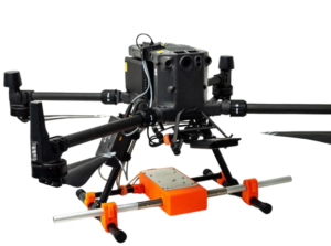
Zond Aero LF — Aerial Low-Frequency
Zond Aero LF is a low-frequency electromagnetic based airborne geophysical survey system designed to identify subsurface anomalies such as valuable minerals, geological structures, and buried mineralized zones...
More
Trimble Alloy
Trimble Alloy adalah receiver GNSS modular yang dirancang untuk kebutuhan survei, pemetaan, monitoring, dan aplikasi presisi tinggi lainnya...
More
Trimble Choke Ring Antenna
Trimble Choke Ring Antenna adalah antena GNSS geodetik presisi tinggi yang dirancang untuk aplikasi permanen seperti CORS (Continuously Operating Reference Station), monitoring deformasi, dan jaringan referensi nasional...
More
Trimble Zephyr 3 Antenna
Trimble Zephyr 3 Antenna adalah antena GNSS presisi tinggi yang merupakan penerus seri Zephyr klasik...
More
Terrasolid – Post Processing Software
Terrasolid is a professional software for large-scale LiDAR data processing and analysis, widely used in topographic mapping, corridor mapping, forestry, electricity, mining, and infrastructure projects...
MorePIX4D Post Processing Software
Pix4Dmapper (PIX4D) is a professional photogrammetry software used to process aerial and terrestrial photos into 2D maps, 3D models, point clouds, DSMs, and DTMs with high accuracy...
MoreAgisoft Metashape – Post Processing Software
Agisoft Metashape is a professional photogrammetry software used to convert photos (aerial and terrestrial) into 3D models, orthomosaics, point clouds, DSMs, and DTMs with high accuracy...
More